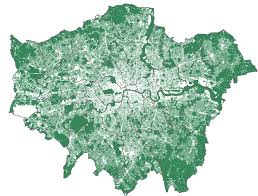
The Greater London Authority has published a new Green Cover Map providing the best picture yet of London's green and blue space. New technology picks out more detailed areas of greenery like small gardens, road verges, green roofs and individual trees for the first time.
The Green Infrastructure Focus Map combines green cover and other data including air quality. Besides being great fun to look at, the map will help councils, developers and others to identify where more, or better-quality green infrastructure will be best employed.